Earth Science worksheet
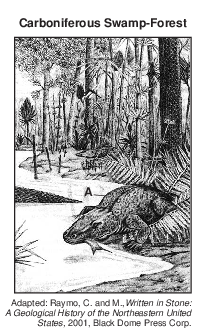
    Topic: Earth Surface Features
    Earth Surface Features
    Base your answers to questions 1 on the drawing below and on your knowledge of Earth science. The drawing represents a swamp-forest environment that existed in North America at the base of the Acadian Mountains during the Carboniferous Period. Organism A lived in this swamp-forest.

    geologic-history, reference-tables, earth-history, evolution-of-life-forms-and-the-free-oxygen-in-the-atmosphere, standard-1-math-and-science-inquery, changing-length-of-a-shadow-based-on-the-motion-of-the-sun, standard-6-interconnectedness, models fig: esci12015-examw_g49.png

    1

    The Acadian Mountains were formed as a result of the collision between North America and

    (1) Avalon

    (2) South America

    (3) Pangaea

    (4) Queenston Delta

    2

    The surface bedrock of Mt. Marcy, New York, is composed primarily of which rock?

    (1) anorthosite

    (2) marble

    (3) quartzite

    (4) hornfels

    3

    New York State bedrock of which age contains salt, gypsum, and hematite?

    (1) Cambrian

    (2) Devonian

    (3) Mississippian

    (4) Silurian

    4

    The block diagram below represents the formation of an island arc near a plate boundary.

    dynamic-earth, earth-surface-features, landscapes, standard-6-interconnectedness, models fig: esci-v202-exam_g18.png

    An island arc is located near the boundary between which two tectonic plates?

    (1) Antarctic Plate and Indian–Australian Plate

    (2) Philippine Plate and Eurasian Plate

    (3) African Plate and North American Plate

    (4) Scotia Plate and South American Plate

    5

    Which two New York State locations have surface bedrock of similar ages?

    (1) Mt. Marcy and Slide Mt.

    (2) Buffalo and Rochester

    (3) Old Forge and Niagara Falls

    (4) Watertown and Albany

    Base your answers to questions 6 on the passage below.

    Crustal Activity at Mid-Ocean Ridges

    Mid-ocean ridges are found at one type of tectonic plate boundary. These ridges consist of extensive underwater mountain ranges split by rift valleys. The rift valleys mark places where two crustal plates are pulling apart, widening the ocean basins, and allowing magma from the asthenosphere to move upward. In some cases, mid-ocean ridges have migrated toward nearby mantle hot spots. This explains why mid-ocean ridges and mantle hot spots are found together at several locations.

    6

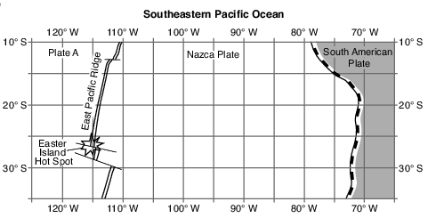
    Which mantle hot spot is located closest to a mid-ocean ridge?

    (1) Canary Islands

    (2) Easter Island

    (3) Hawaii

    (4) Tasman

    7

    The formation of the Canary Islands was primarily caused by their location near a

    (1) subduction zone

    (2) mantle hot spot

    (3) divergent boundary

    (4) transform fault

    8

    The block diagram below represents two parallel mountain ranges.

    dynamic-earth, earth-surface-features, landscapes, dynamic-earth, landforms, landscapes, standard-6-interconnectedness, models fig: esci12017-examw_g11.png

    Which two geologic processes most likely created this landscape region?

    (1) volcanism, followed by metamorphism

    (2) faulting, followed by deposition

    (3) folding, followed by erosion

    (4) glaciation, followed by rifting

    Base your answers to questions 9 on the passage below and on your knowledge of Earth science.

    Island Arcs

    Island arcs are long, curved chains of oceanic islands associated with seismic activity and mountain-building processes at certain plate boundaries. They occur where oceanic tectonic plates collide. Along one side of these island arcs, there is usually a long, narrow deep-sea trench.

    At island arcs, the denser plate is subducted and is forced into the partially molten mantle under the less dense plate. The islands are composed of the extrusive igneous rocks basalt and andesite. The basalt originates most likely from the plastic mantle. The andesite originates most likely from the melting of parts of the descending plate and sediments that had accumulated on its surface.

    9

    An island arc is found along the

    (1) East Pacific Ridge

    (2) Iceland Hot Spot

    (3) Aleutian Trench

    (4) Peru-Chile Trench

    Base your answers to questions 10 on the map in image provided, on the table below, and on your knowledge of Earth science. The map shows a portion of the Nazca Plate under the southeastern Pacific Ocean. Plate A represents another tectonic plate. The table shows some data for islands and seamounts (undersea volcanoes that do not rise above the ocean surface) that originally formed at the Easter Island Hot Spot.

    dynamic-earth, earth-surface-features, landscapes, standard-1-math-and-science-inquery, eccentricity-rate-gradient-standard-error, standard-6-interconnectedness, models fig: esci-v202-exam_g44.png

    10

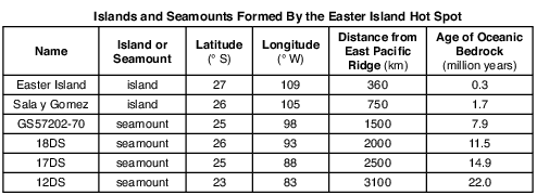
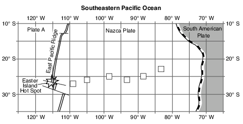
    On the map in the image provided, plot with Xs the locations of the six islands and seamounts formed by the Easter Island Hot Spot. [1]

    dynamic-earth, earth-surface-features, landscapes, standard-1-math-and-science-inquery, eccentricity-rate-gradient-standard-error, standard-6-interconnectedness, models fig: esci-v202-ansbk_abkq1.png

    Allow 1 credit if the centers of all six Xs are within or touch the clear boxes shown below.. Note: Allow credit if a symbol other than an X is used.

    • It is recommended that an overlay of the same scale as the student answer sheet be used to ensure reliability in rating.

    dynamic-earth, earth-surface-features, landscapes, standard-1-math-and-science-inquery, eccentricity-rate-gradient-standard-error, standard-6-interconnectedness, models fig: esci-v202-rg_g1.png

    Base your answers to questions 11 on the cross section in image provided and on your knowledge of Earth science. The cross section represents several geologic structures. Line AB represents a fault. C and D represent rock units.
    11

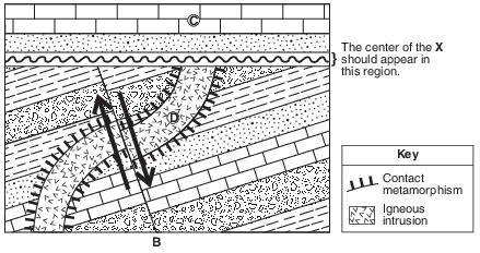
    On the cross section in the image provided, place two arrows, one on each side of fault AB, to show the relative movement of the rock units on each side of the fault. [1]

    Allow 1 credit for the correct placement of both arrows as shown below.

    • Example of a 2-credit response for questions 83 and 84:

    dynamic-earth, earth-surface-features, landscapes, standard-1-math-and-science-inquery, changing-length-of-a-shadow-based-on-the-motion-of-the-sun, standard-6-interconnectedness, models fig: esci62013-rg_g6.png

    Base your answers to questions 12 on the cross section below and on your knowledge of Earth science. The cross section represents rock formations that exist in the southwestern part of the United States. Names of the faults and rock units are indicated on the diagram.

    rocks-and-minerals, formation-classification-and-application-of-rocks, standard-6-interconnectedness, systems-thinking, standard-6-interconnectedness, models fig: esci82013-exam_g36.png

    12

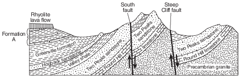
    Explain why the Two Peaks sandstone is not a continuous layer. [1]

    Allow 1 credit. Acceptable responses include, but are not limited to:

    • — Faulting displaced the sandstone layer.

    • — Two Peaks sandstone was broken by faults in two locations.

    • — faulting

    Base your answers to questions 13 on the cross section of part of Earth’s crust in image provided and on your knowledge of Earth science. On the cross section, some rock units are labeled with letters A through I. The rock units have not been overturned. Line XY represents a fault. Line UV represents an unconformity.
    13

    Write the letter of the oldest rock unit in the cross section. [1]

    Allow 1 credit for F.

    Base your answers to questions 14 on the block diagram in image provided and on your knowledge of Earth science. The diagram represents the pattern of normal and reversed magnetic polarity of the seafloor bedrock on the east side of a mid-ocean ridge center. The magnetic polarity of the bedrock on the west side of the ridge has been omitted. Arrows represent the direction of seafloor movement on either side of the ridge.
    14

    Complete the diagram in the image provided by shading the pattern of normal polarity on the west side of the ridge center. Assume the rate of plate movement was constant on both sides of the ridge center. Your answer must show the correct width and placement of each normal polarity section. [1]

    dynamic-earth, earth-surface-features, landscapes, standard-6-interconnectedness, models, standard-6-interconnectedness, patterns-of-change fig: esci12014-ansbk_abkq4.png

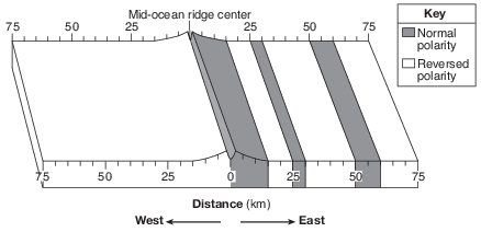
    Allow 1 credit if the width and placement of the shading have been correctly indicated on either the surface and/or the side view.

    • Example of a 1-credit response:

    dynamic-earth, earth-surface-features, landscapes, standard-6-interconnectedness, models, standard-6-interconnectedness, patterns-of-change fig: esci12014-rg_g4.png

    Base your answers to questions 15 on the map in image provided and on your knowledge of Earth science. The map shows the generalized ages of surface bedrock of Iceland, an island located on the Mid-Atlantic Ridge rift. The location of the Mid-Atlantic Ridge rift is indicated. Points A and B represent locations on the surface bedrock, which is igneous in origin. The ages of the surface bedrock, in million years (my), are indicated in the key.
    15

    Identify one feature in the mantle beneath Iceland that causes larger amounts of magma formation in Iceland than at most other locations along the rest of the Mid-Atlantic Ridge rift. [1]

    Allow 1 credit. Acceptable responses include, but are not limited to:

    • — Iceland is over a mantle hot spot.

    • — A mantle plume rises in the region.

    • — Iceland Hot Spot

    • Note: Do not allow credit for “diverging plate,” “convection currents,” or “rising magma” because

    • they occur mostly along the rest of the Mid-Atlantic Ridge rift.